
Unclassified Imagery Data
CRI has accumulated a massive database of unclassified aerial and ground-based imagery through many thousands of hours of WAMI, HDM, Guardian IIS, and LongShot data collection. We can provide this high quality imagery for use with mapping, artificial intelligence, machine learning, and many more applications. With this source data, you can confidently take your projects to the next level.
Available Imagery:
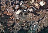
WAMI
CRI has a vast amount of WAMI unclassified aerial data of North America during each season of the year captured from 5,000ft to 15,000ft. Captures include a variety of rural, industrial, city and wildlife imaging.
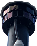
Guardian IIS
CRI has a large quantity of data recorded from Guardian IIS recordings. Guardian IIS data consists of an array of images which are spatially adjacent to one another. This data can be used for tracking an individual from camera to camera across a scene.
HDM Imagery
We also have assortment of High Definition Multispectral imagery available. This imagery was captured using our LodeStar HDM equipped with an EO, SWIR, and MWIR sensors. Images are aligned to allow for image fusing.
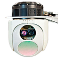
LongShot
Our LongShot system captures the same scene with various co-aligned cameras with different focal lengths. This produces images of the same target at different levels of resolution. This data is useful for machine learning as well as algorithmic image processing.
